The 2009 Station fire was the 10th largest megafire in California since 1933, lasting from August 26th to October 16th. The Station fire was responsible for burning 160,577 acres of the Angeles National Forest, destroying 209 structures, and killing 2 firefighters. Map 1 shows the total area of the Station fire as of September 2nd. The fire was a result of arson near the U.S. Forest Service ranger station which was concluded from an unidentified substance at the source of the blaze. The arsonist has not been caught and there is a $150,000 reward for information leading to the conviction of the arsonist.
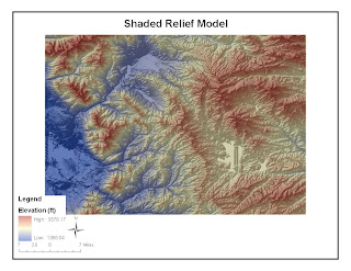
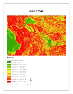
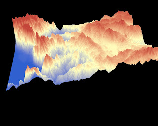
Southern California weather conditions and terrain made this fire so devastating. Droughts are not uncommon to the area, often lasting years; Southern California is currently on its fourth straight year of below average rainfall. Lack of precipitation combined with dry and hot summers makes Southern California prone to wildfires. Once wildfires start, the terrain becomes an issue. Fire travels quickly uphill and steep terrain restricts access for firefighters. Map 2 is a slope map of the San Gabriel Mountains to better illustrate the terrain. Notice that the terrain primarily has slopes greater than 60 degrees.
The fire was attacked from firefighters on the ground and from water-dropping aircraft. Only 38% of the fire was contained by September 3rd, costing $27 million. The northern and western perimeters of the fire were the first to be controlled to protect as many houses as possible. This is demonstrated in Map 1 because the fire slowed its advances north and west over time. Shortly thereafter, the focus shifted to the southern perimeter to protect the 210 freeway as flames got so close to the freeway that they were visible to drivers. By September 15th, 91% of the fire was contained and $93.8 million had been spent battling the fire. The fires were 100% contained on October 16th due to moderate rainfall.
The consequences of the Station fire still continue and they affect all of Los Angeles County. Debris and oil left from burnt chaparral bring the threat of mudslides to homeowners and reservoirs when winter rains come. The Angeles Forest watershed, which makes up 35% of the Los Angeles area water supply, has been damaged because now there are no shrubs to direct water. Finally, 40 miles of State Highway 2 have been closed indefinitely due to fire damage.
Residents placed initial blame on the government and land managers because they did not clear “underbrush” which presumably provided fuel for the fire. They request stripping some of the backcountry of native shrubs like manzanita and chaparral to create fire buffers and protect their homes. Not only would this action destroy wildlands but it would also allow potentially flammable weeds to grow in their place. In fact, underbrush is not even the problem. A report was released stating that the cause of the spread was actually the terrain, which didn’t allow for quick action from firefighters. The only way the spread of the fire could have been limited was starting water-dropping aircraft sooner. I believe safety measures such as sprinkler systems should be implemented by structures in regions prone to wildfires (i.e. homes, businesses, roads) to reduce the negative impacts of future wildfires.
References:
1) "2009 California wildfires." wikipedia.org. Web. 19 Nov. 2009
2) "Station Fire: Incident Updated 11/10/2009." inciweb.org. Web. 20 Nov. 2009
3) Boxall, Winton. "Reward for arsonist in Station fire could top $150,000 today." latimes.com. 8 Sep. 2009. Web. 20 Nov. 2009
4) Becerra. "Southern California wraps up 4th straight year of below-average rainfall." latimes.com. 29 June 2009. Web. 20 Nov. 2009
5) Starr. "Firefighters close to containing half of Station fire." cnn.com. 3 Sep. 2009. Web. 20 Nov. 2009
6) Pringle. "U.S. Forest Service report: Station fire terrain too steep to fight safely." latimes.com. Web. 19 Nov. 2009
7) SteamGeek. "LA Water Supply in Danger From the Station Fire?" nowpublic.com. Web. 19 Nov. 2009
8) Allen. "Perspective on SoCal Wildfires - Station Fire, 2009." californiagreensolutions.com. Web. 20 Nov. 2009


